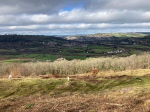
A varied circular walk taking in a quaint Cotswold village, farmland and riverside before reaching the Scheduled Ancient Monument of Dundas Aqueduct. Return via a canal stroll followed by a climb to Browne’s Folly for panoramic views. Also makes quite a good pub crawl!
Download the pdf for the full description and map
Start & Finish: Outside the Kings Arms, Monkton Farleigh, Bradford on Avon BA15 2QH *W3W – movement.operation.arts
Distance: 8 mile / 12.9 km with an up and down of 1035ft / 315 m
Slopes: A steady descent to start and a steep ascent at the end, long flat sections in the middle.
Steps & stiles: Several step sets, one stone stile, several wooden stiles
Terrain: Pavement, unpaved paths, paved tow path and minor roads.
Transport: Visit travelinesw.com. Bus Stop outside the Kings Arms on Farleigh Rise, Monkton Farleigh runs once a day. This route can be accessed by public transport at Bathford, Bathampton and Dundas Basin. Free parking available in the village. Please park respectfully.
Public toilets: Somersetshire Coal Canal Centre
Refreshments: The Kings Arms, Monkton Farleigh, a short detour to the Angelfish café from Dundas Aqueduct, The George Inn, Bathampton or The Crown at Bathford.
Rest points: Benches at Dundas Aqueduct, canal side at Bathampton and in the churchyard of St. Swithun’s in Bathford.
Dogs welcome: Yes, though livestock in some fields so please be prepared to put them on a lead.
Wheel friendly: No
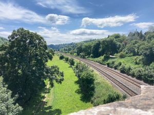
Features on the route: Dundas Aqueduct, River Avon, Railway line, Kennet & Avon Canal, Claverton Pumping Station, Browne’s Folly Nature Reserve and Tower.